


Preview
Identifier
20086369
Description
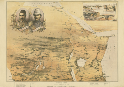
This map of the Soudan and surrounding countries, published as a supplement to the Illustrated London News in 1884, includes inset portraits of General Gordon (Governor-General of Sudan) and Colonel Stewart (second in command) in the top left corner. In the top right corner it has four small views of Kartoum, Mudir's Palace, the defile of Karaza Kordofan and El Obeid. The map covers areas of the Congo, Zaire, Zambia, Tanzania, Uganda, Kenya, Somalia, Ethiopia, Sudan and Egypt. Between March-June 1885, the NSW Contingent served in Sudan, Africa. The contingent, an infantry battalion of 522 men and 24 officers and an artillery battery of 212 men, was ready to sail on 3 March 1885. It left Sydney amid much public fanfare, generated in part by the holiday declared to farewell the troops; the send-off was described as the most festive occasion in the colony's history. The NSW contingent anchored at Suakin, Sudan's Red Sea port, on 29 March 1885 and were attached to a brigade composed of Scots, Grenadiers and Coldstream Guards. Shortly after their arrival they marched as part of a large "square" formation -on this occasion made up of 10,000 men - for Tamai, a village some 30 kilometres inland. Not having participated in any battles, Australian casualties were few: those who died fell to disease rather than enemy action. By May 1885 the British government had decided to abandon the campaign and left only a garrison in Suakin. The Australian contingent sailed for home on 17 May 1885, arriving back in Sydney on 19 June. It was generally agreed at the time that, no matter how small the military significance of the Australian contribution to the War in Sudan, it marked an important stage in the development of colonial self-confidence and was proof of the enduring link with Britain. Double page chromolithograph supplement. Double paged, bound on backside. 40.9 cm. x 57.7 cm. [Gift of Dr. Jack Franke]
Archival Date
1884
Collection Name
Maps of Africa
Collection Number
Acc. 2019-201
Language
English
Original Format
Maps
File Format
JPG
Rights
Rights held by The University of Texas at Arlington Libraries, Special Collections. Any use of content downloaded or printed from this page is limited to non-commercial personal or educational use, including fair use as directed by U.S. copyright laws. For more information or for reproduction requests, please contact UTA Special Collections by emailing spcoref@uta.edu.
License

This work is licensed under a Creative Commons Attribution-NonCommercial 4.0 International License
Subjects
Maps; Africa; Vignettes; Madagascar; Children's atlases; Illustrations; Borders (Ornament areas)