


Preview
Identifier
20086366
Description
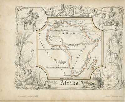
Map of Africa from a German kinderatlas or children's atlas. The map covers the entire continent from the Mediterranean Sea to Cape Town. Also includes the island of Madagascar. The whole is surrounded by a wide boarder featuring vignettes meant to illustrate the peoples and cultures of the region. These include a tiger being strangled by an anaconda, a camel, a crocodile, a giraffe, monkeys, and equestrian figures. The map is accompanied by its adjacent page of text, which includes a poetic history of Africa in German Gothic type. The map was drawn by Anst. V A. Boeden of Berlin for inclusion as plate no. XVIII in the 1846 issue of Julius Loewenberg's "Geographische Landerfibel." Horizontal, double paged, double sided pages of German text accompanied with horizontal, single paged, and single sided map of African continent. 14 cm. x 17 cm. [Gift of Dr. Jack Franke]
Archival Date
1846
Collection Name
Maps of Africa
Collection Number
Acc. 2019-236
Language
German
Original Format
Maps
File Format
JPG
Rights
Rights held by The University of Texas at Arlington Libraries, Special Collections. Any use of content downloaded or printed from this page is limited to non-commercial personal or educational use, including fair use as directed by U.S. copyright laws. For more information or for reproduction requests, please contact UTA Special Collections by emailing spcoref@uta.edu.
License

This work is licensed under a Creative Commons Attribution-NonCommercial 4.0 International License
Subjects
Maps; Africa; Vignettes; Madagascar; Children's atlases; Illustrations; Borders (Ornament areas)