


Preview
Identifier
20086362
Description
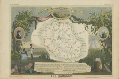
Hand-colored map of Reunion island by Victor Levasseur with pictorial illustrations by Raimond Bonheur, father of the famous French artist Rosa Bonheur. Reunion island, formerly known as Ile Bourbon, is a volcanic island off the coast of Africa with rainforest interior and Creole culture. Surrounding the map are vignettes and imagery, including portraits of French poets Evariste de Parny (left) and Antoine Bertin (right), island natives, and plants indigenous to the island. A volcano and harbor town scene are included, with vegetal resources presented beside storage containers. Map from Levasseur's Atlas National Illustre (Paris: A. Combette, 1845, and later editions). Single-sided, side-paged, horizontal map. 28 cm. x 43 cm. [Gift of Dr. Jack Franke]
Archival Date
1849
Collection Name
Maps of Africa
Collection Number
Acc. 2019-244
Language
French
Original Format
Maps
File Format
JPG
Rights
Rights held by The University of Texas at Arlington Libraries, Special Collections. Any use of content downloaded or printed from this page is limited to non-commercial personal or educational use, including fair use as directed by U.S. copyright laws. For more information or for reproduction requests, please contact UTA Special Collections by emailing spcoref@uta.edu.
License

This work is licensed under a Creative Commons Attribution-NonCommercial 4.0 International License
Subjects
Maps; Africa; Réunion; Islands; Waterways; Colonies; Illustrations; Volcanoes; Oceans