


Preview
Identifier
20086361
Description
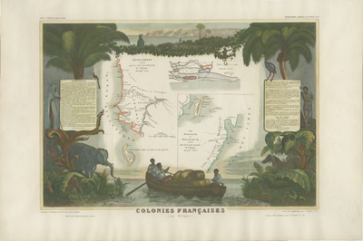
Colored, decorative map of the French colonies in Africa, divided into three sections dedicated to Senegambie (Senegambia), Madagascar, and the Senegal River. The largest focus is on Senegambia, with an inset of the Island of Goree in the lower left. Depicted around map border are illustrations of tropical environment with indigenous peoples, wild life of flora and fauna, and local inhabitants traveling by boat with cargo. Scrolls shown to left and right of map with text explanation and statistics in French. Publisher information and title of map located within bottom margin. Scale and additional title located within map, between Senegambia and Madagascar. Illustrated by French painter Raimond Bonheur, father of the famous French artist Rosa Bonheur. From Victor Levasseur's Atlas National Illustre (Paris: A. Combette, 1845 and later editions). Single page, single sided, horizontal map. 28 cm. x 43. cm. [Gift of Dr. Jack Franke]
Archival Date
1849
Collection Name
Maps of Africa
Collection Number
Acc. 2019-245
Language
French
Original Format
Maps
File Format
JPG
Rights
Rights held by The University of Texas at Arlington Libraries, Special Collections. Any use of content downloaded or printed from this page is limited to non-commercial personal or educational use, including fair use as directed by U.S. copyright laws. For more information or for reproduction requests, please contact UTA Special Collections by emailing spcoref@uta.edu.
License

This work is licensed under a Creative Commons Attribution-NonCommercial 4.0 International License
Subjects
Maps; Africa; Illustrations; Animals; People; Boats; Madagascar; Islands