


Preview
Identifier
20086358
Description
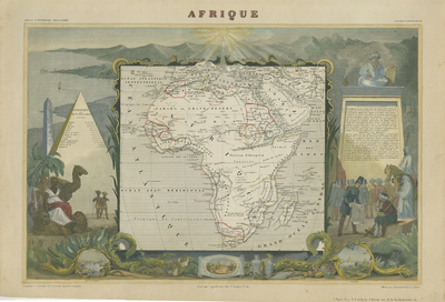
Colorful map of Africa from Levasseur's "Atlas Universel Illustre." Illustrated are references to the continent's fauna and flora including lions, camels and crocodiles; a pyramid of ancient Egypt; ornate neo-rococo framed vignette views of Alexandria, Cairo and Algiers; native people of Arabia and Africa, and the French army laying claim to Algeria. Border around map includes imagery and scenes in comprehensive color. Statistical data is included left and right of the map, on the pyramid and monolith. Publisher information located within bottom margin and title located at top center. Much of the interior is vague and unmapped, except for the northern Nile Valley, the French colonies in Senegal, Gambia, and Algeria, and the colonies of the Dutch and English in South Africa, each region distinguished by originally hand-colored boundaries. A semi-accurate mapping of the Niger, which is uncommon for the period, is also depicted here. The map correctly identifies Lake Chad. Single-paged, single-sided horizontal map. 28 cm. x 43 cm. [Gift of Dr. Jack Franke]
Archival Date
1849
Collection Name
Maps of Africa
Collection Number
Acc. 2019-243
Language
French
Original Format
Maps
File Format
JPG
Rights
Rights held by The University of Texas at Arlington Libraries, Special Collections. Any use of content downloaded or printed from this page is limited to non-commercial personal or educational use, including fair use as directed by U.S. copyright laws. For more information or for reproduction requests, please contact UTA Special Collections by emailing spcoref@uta.edu.
License

This work is licensed under a Creative Commons Attribution-NonCommercial 4.0 International License
Subjects
Maps; Africa; Oceans; Islands; Waterways; Illustrations; Animals; Armies; Mountains