


Preview
Identifier
20086357
Description
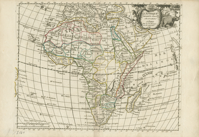
Uncolored map of Africa and its surrounding islands, from Le Rouge's "Atlas nouveau portatif à l'usage des militaires et du voyageur," published in Paris, 1748. Neighboring regions include southern Europe, the Levant region, Turkey, and Arabia. Minor reference to geographical context of Brazil depicted west. Regions outlined by various colors. Decorative title cartouche depicts figure mounted on horseback (left), beside several elephants (right), within outdoor local setting. Border around map includes scale. Scale key, located in bottom left corner, provides two different scale measurements. Portions of map extend beyond the surrounding scale border. Hachures lightly depicted off coast(s). Locale of various kingdoms and ethnic groups noted. Landforms and waterways generally included throughout. Double-paged, single-sided, horizontal map on laid paper. Bound at centrefold on verso. Verso is blank. 20 cm. x 28 cm. [Gift of Dr. Jack Franke]
Archival Date
1748
Collection Name
Maps of Africa
Collection Number
Acc. 2019-283
Language
French
Original Format
Maps
File Format
JPG
Rights
Rights held by The University of Texas at Arlington Libraries, Special Collections. Any use of content downloaded or printed from this page is limited to non-commercial personal or educational use, including fair use as directed by U.S. copyright laws. For more information or for reproduction requests, please contact UTA Special Collections by emailing spcoref@uta.edu.
License

This work is licensed under a Creative Commons Attribution-NonCommercial 4.0 International License
Subjects
Maps; Africa; Oceans; Islands; Waterways; Cartouches (Graphic)