


Preview
Identifier
20086359
Description
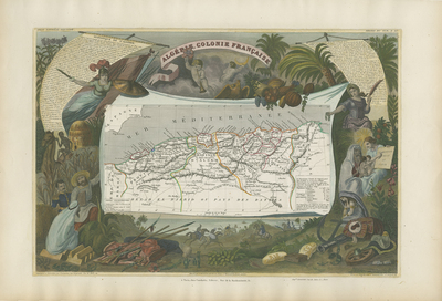
Colorful map by Victor Levasseur, illustrated by A. M. Perrot and Raimond Bonheur, engraved by Laguillermie and Rainaud, and printed by the firm of Lemercier in Paris. It depicts the northern Africa region of French Algeria with the three provinces of Oran, Alger and Constantine delineated in contrasting colors. Topographical features are shown and major cities, towns, deserts, waterways, and land routes are located. Surrounding the map are scenes with allegorical, religious, and military figures, along with other people, flora and fauna indigenous to the region. Littering the foreground are gold ingots, weapons including spears, dirks or scimitars, Kabyle muskets, a busted cannon, as well as broken shackles or manacles, bags of rice and salt, an anchor, and a discarded saddle. Notably beneath the map is a scene of a lion hunt with four figures mounted on horseback. Statistical information on Algeria available within banners within top left and right. From Victor Levasseur's Atlas National Illustre (Paris: Combette, first published in 1845 with later editions). Single-sided, single-paged horizontal map. 28 cm. x 43 cm. [Gift of Dr. Jack Franke]
Archival Date
1854
Collection Name
Maps of Africa
Collection Number
Acc. 2019-246
Language
French
Original Format
Maps
File Format
JPG
Rights
Rights held by The University of Texas at Arlington Libraries, Special Collections. Any use of content downloaded or printed from this page is limited to non-commercial personal or educational use, including fair use as directed by U.S. copyright laws. For more information or for reproduction requests, please contact UTA Special Collections by emailing spcoref@uta.edu.
License

This work is licensed under a Creative Commons Attribution-NonCommercial 4.0 International License
Subjects
Maps; Africa; Illustrations; Animals; People