


Preview
Identifier
20086354
Description
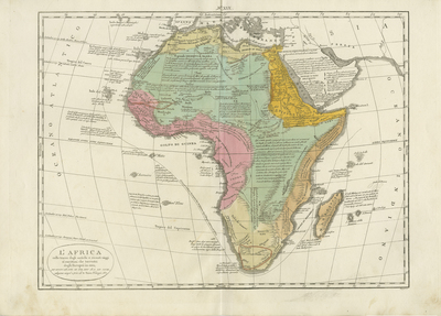
Colored map of Africa and its islands. Surrounding regions of Arabia and Mediterranean depicted. Colors distinguish general regions within continent. Includes notes on early European exploration of Africa with mention of the 15th-century Portuguese voyages along the west coast, of the continent, the Canary, and Cape Verde Islands. Annotations throughout map. Includes comments about voyages of Vasco de Gama in 1497 and 1498 around the Cape of Good Hope and Marco Polo's voyage to Madagascar. A descriptive text elegantly portrays Africa, using words to draw out the unique coastlines and island formations of the region. Landforms are also depicted and located within continent. Simply decorated cartouche located at bottom left. Surrounding border of map is undecorated, including scale. Roman numerals XIX printed at top centrefold. Single sided, double page, horizontal map of Africa. Bound at centrefold on verso. 36 cm. x 46 cm. [Gift of Dr. Jack Franke]
Archival Date
1830
Collection Name
Maps of Africa
Collection Number
Acc. 2019-281
Language
Italian
Original Format
Maps
File Format
JPG
Rights
Rights held by The University of Texas at Arlington Libraries, Special Collections. Any use of content downloaded or printed from this page is limited to non-commercial personal or educational use, including fair use as directed by U.S. copyright laws. For more information or for reproduction requests, please contact UTA Special Collections by emailing spcoref@uta.edu.
License

This work is licensed under a Creative Commons Attribution-NonCommercial 4.0 International License
Subjects
Maps; Africa; Oceans; Islands; Cartouches (Graphic); Capes (Coasts); Discovery & exploration