


Preview
Identifier
20086353
Description
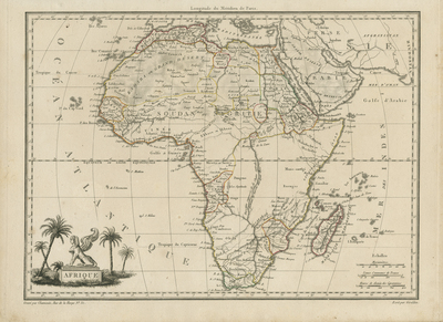
Copper engraved, uncolored map of Africa by Conrad Malte-Brun, produced to accompany the "Atlas Complet du Precis de la Geographie Universelle," first published in Paris, 1812. Cartouche in lower left of title within pedestal, holding a seated sphinx with wings and date palms surrounding. Border around map includes scale. Scale key located at bottom right. Regions delineated by different colored outlines. Hachures depicted off coast(s). Neighboring regions of southern Mediterranean, Arabia, and Persia included as well as African islands surrounding mainland. Reference to Hindustan region located in far right. Tribes, landforms, and waterways located throughout map. Publisher information located within bottom margin. Single-paged, single-sided, horizontal map without centrefold or binding. 29 cm. x 30 cm. [Gift of Dr. Jack Franke]
Archival Date
1812
Collection Name
Maps of Africa
Collection Number
Acc. 2019-228
Language
French
Original Format
Maps
File Format
JPG
Rights
Rights held by The University of Texas at Arlington Libraries, Special Collections. Any use of content downloaded or printed from this page is limited to non-commercial personal or educational use, including fair use as directed by U.S. copyright laws. For more information or for reproduction requests, please contact UTA Special Collections by emailing spcoref@uta.edu.
License

This work is licensed under a Creative Commons Attribution-NonCommercial 4.0 International License
Subjects
Maps; Africa; Oceans; Mountains; Rivers; Islands; Cartouches (Graphic)