


Preview
Identifier
20086350
Description
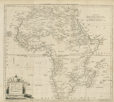
An uncolored, copper engraved map of Africa depicting typical late 18th century knowledge of the continent. Map spans from Spain and Anatolia in north, to the Cape of Good Hope, in the south. Includes neighboring regions of Arabia and Levant generally for geographical context. Islands off mainland Africa depicted. The Cape of Good Hope extends beyond border of map. The Nile is shown originating from twin lakes of "Mountains of the Moon" believed to be located above the equator. Uncolored title cartouche in bottom left corner features African royal with a lion, ostrich, and camel beside distant pyramids to the right. Locale of various tribes noted. Compass rose provided within Ethiopian Sea. Border surrounding map includes scale. Scale key located in upper right corner with two scale measurements. Landforms and waterways located throughout. Hachures used to indicate coastlines along the continent's landmass. Publisher information provided within top margin. Single-paged, single-sided, horizontal map. 34 cm. x 38 cm. [Gift of Dr. Jack Franke]
Archival Date
1782
Collection Name
Maps of Africa
Collection Number
Acc. 2019-304
Language
English
Original Format
Maps
File Format
JPG
Rights
Rights held by The University of Texas at Arlington Libraries, Special Collections. Any use of content downloaded or printed from this page is limited to non-commercial personal or educational use, including fair use as directed by U.S. copyright laws. For more information or for reproduction requests, please contact UTA Special Collections by emailing spcoref@uta.edu.
License

This work is licensed under a Creative Commons Attribution-NonCommercial 4.0 International License
Subjects
Maps; Africa; Waterways; Oceans; Mountains; Rivers; Lakes; Islands; Cartouches (Graphic)