


Preview
Identifier
20086348
Description
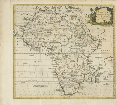
This uncolored map of Africa was produced to accompany William Guthrie's "A New System of Modern Geography," published by C. Dilly and G. Robinson, London 1780. Map includes neighboring regions of southern Mediterranean, Levant, and Arabia. Includes islands off mainland Africa. European knowledge of tribal information, locale of various tribes, and dignitaries noted throughout. Colored title cartouche features three indigenous inhabitants generally (female, child, and male) dressed apparently locally, with flora/vegetation surrounding, and indigenous building in the distance. Regions within continent outlined by various colors. Cape Verde islands extend past border of map. Border surrounding map includes scale. Scale key provided in lower left corner. Compass rose printed within Ethiopian Sea. Resources, landforms and waterways located throughout. Single-paged, single-sided, horizontal map. 34 cm. x 37 cm. [Gift of Dr. Jack Franke]
Archival Date
1780
Collection Name
Maps of Africa
Collection Number
Acc. 2019-166
Language
English
Original Format
Maps
File Format
JPG
Rights
Rights held by The University of Texas at Arlington Libraries, Special Collections. Any use of content downloaded or printed from this page is limited to non-commercial personal or educational use, including fair use as directed by U.S. copyright laws. For more information or for reproduction requests, please contact UTA Special Collections by emailing spcoref@uta.edu.
License

This work is licensed under a Creative Commons Attribution-NonCommercial 4.0 International License
Subjects
Maps; Africa; Waterways; Seas; Islands; Cartouches (Graphic)