


Preview
Identifier
20086349
Description
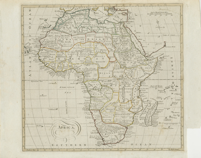
Uncolored map of Africa and its surrounding islands. Neighboring regions of southern Mediterranean, Levant, and Arabia generally included. Most maps of Africa at the time were full of speculation; this particular map is no exception. The White Nile flows south into the Ptolemaic Lunar Mountains or the Mountains of the Moon. A network of rivers also extends westward from the White Nile, most likely based on the belief that the Nile may be connected to the Niger River. Lake Malawi appears in its long embryonic form with its northern banks incomplete. The Lake was not officially discovered until 1849 (after this map was made). Simply decorative title cartouche located in lower left corner. Scale key located at top right. Border surrounding map includes scale. Regions throughout are outlined by various colors. Compass Rose provided in top right, beneath scale key. Locale of various tribes and early African kingdoms noted. Landforms and waterways depicted throughout continent. Single-sided, single-paged, horizontal map. 53 cm. x 55 cm. [Gift of Dr. Jack Franke]
Archival Date
1770
Collection Name
Maps of Africa
Collection Number
Acc. 2019-303
Language
English
Original Format
Maps
File Format
JPG
Rights
Rights held by The University of Texas at Arlington Libraries, Special Collections. Any use of content downloaded or printed from this page is limited to non-commercial personal or educational use, including fair use as directed by U.S. copyright laws. For more information or for reproduction requests, please contact UTA Special Collections by emailing spcoref@uta.edu.
License

This work is licensed under a Creative Commons Attribution-NonCommercial 4.0 International License
Subjects
Maps; Africa; Waterways; Oceans; Mountains; Rivers; Lakes; Islands; Cartouches (Graphic)