


Preview
Identifier
20086347
Description
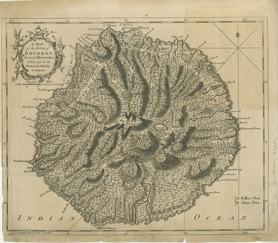
Uncolored map of Isle of Bourbon, modernly known as Reunion Island, published in London Magazine. Map provides great detail and high relief in depictions of vegetation, waterways, landforms, and topographical features within island. Transportation routes, ports, and settlements noted throughout map. Small fleur-de-lis motif, near 54 degree mark in upper right corner. Hachures depicted around island coast. Border surrounding map includes scale. Scale key provided beneath decorative title cartouche located in top left corner. Small additional key provided in lower right. Single-paged, single-sided, horizontal map. 23 cm. x 28 cm. [Gift of Dr. Jack Franke]
Archival Date
1762
Collection Name
Maps of Africa
Collection Number
Acc. 2019-294
Language
English
Original Format
Maps
File Format
JPG
Rights
Rights held by The University of Texas at Arlington Libraries, Special Collections. Any use of content downloaded or printed from this page is limited to non-commercial personal or educational use, including fair use as directed by U.S. copyright laws. For more information or for reproduction requests, please contact UTA Special Collections by emailing spcoref@uta.edu.
License

This work is licensed under a Creative Commons Attribution-NonCommercial 4.0 International License
Subjects
Maps; Africa; Réunion; Islands; Harbors; Waterways; Colonies; Cartouches (Graphic)