


Preview
Identifier
20086327
Description
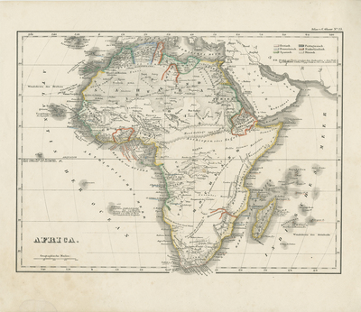
Uncolored map of Africa, with original hand-colored outlines, from Carl Gläser's Hand-Atlas über alle Theile der Erde..., published in Stuttgart by Scheitlin & Krais in 1850. Coastal regions outlined with color, rest of map uncolored. Stippling printed for desert regions, mountain ranges located, and hachures included to designate coastline(s) along the continent and nearby islands. Title and scale are located in bottom left. Legend in upper right, lists European colonial holdings designated by color, and outlined within continent. Border of map includes scale. Single sided, single paged, horizontal map with original hand color outline. Verso blank. 20 cm. x 25 cm. [Gift of Dr. Jack Franke]
Archival Date
1848
Collection Name
Maps of Africa
Collection Number
Acc. 2019-384
Language
German
Original Format
Maps
File Format
JPG
Rights
Rights held by The University of Texas at Arlington Libraries, Special Collections. Any use of content downloaded or printed from this page is limited to non-commercial personal or educational use, including fair use as directed by U.S. copyright laws. For more information or for reproduction requests, please contact UTA Special Collections by emailing spcoref@uta.edu.
License

This work is licensed under a Creative Commons Attribution-NonCommercial 4.0 International License
Subjects
Maps; Africa; Colonies; Deserts; Mountains; Oceans