


Preview
Identifier
20086324
Description
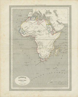
Uncolored map showing Northern Africa during the mid-19th century. Regions within Numidia and Mauritania are distinguished by colored outlines. Map includes surrounding regions of Spain, southern Italy, and some of Greece. Located at bottom center of map includes title and scale for distance shown in meters and Roman miles. Lower left corner has inset showing city plan of Carthage. Double-paged, single-sided, horizontal map with centrefold and binding on verso. 24 cm. x 32 cm. [Gift of Dr. Jack Franke]
Archival Date
1852
Collection Name
Maps of Africa
Collection Number
Acc. 2019-359
Language
Spanish
Original Format
Maps
File Format
JPG
Rights
Rights held by The University of Texas at Arlington Libraries, Special Collections. Any use of content downloaded or printed from this page is limited to non-commercial personal or educational use, including fair use as directed by U.S. copyright laws. For more information or for reproduction requests, please contact UTA Special Collections by emailing spcoref@uta.edu.
License

This work is licensed under a Creative Commons Attribution-NonCommercial 4.0 International License
Subjects
Maps; Africa; Africa; Seas; Waterways; Islands; Mountains; City planning