


Preview
Identifier
20086318
Description
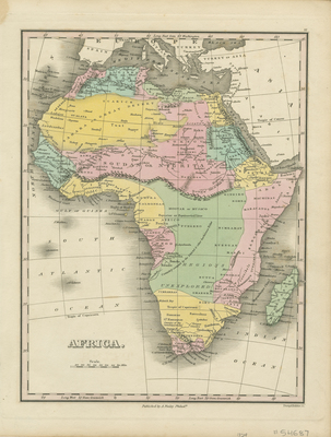
First edition of Anthony's Finley's map of Africa, published in Philadelphia, from Finley's "New General Atlas." Colored map with regions and colonial possessions delineated by color. No color key provided for regions. Central Africa is largely labeled as unexplored. Neighboring regions of Arabia, Turkey, southern Europe, and surrounding African islands depicted. Hachures printed along coast of Africa and around island coasts. Landforms and waterways located throughout. Border around map includes scale. Title and scale of map located in bottom left corner. Publisher information in center bottom margin. Single-paged, single-sided, vertical map. 29 cm. x 23 cm. [Gift of Dr. Jack Franke]
Archival Date
1824
Collection Name
Maps of Africa
Collection Number
Acc. 2019-342
Language
English
Original Format
Maps
File Format
JPG
Rights
Rights held by The University of Texas at Arlington Libraries, Special Collections. Any use of content downloaded or printed from this page is limited to non-commercial personal or educational use, including fair use as directed by U.S. copyright laws. For more information or for reproduction requests, please contact UTA Special Collections by emailing spcoref@uta.edu.
License

This work is licensed under a Creative Commons Attribution-NonCommercial 4.0 International License
Subjects
Maps; Africa; Oceans; Waterways; Islands; Colonies