


Preview
Identifier
20086317
Description
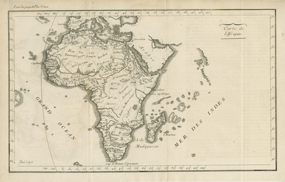
Uncolored map of Africa, including surrounding islands and Madagascar, from the "METHODE POUR ETUDIER L’HISTOIRE," by L’Abbe Lenglet du Fresnoy, published in Paris, 1729. Neighboring regions of southern Europe and Arabia featured, with little detail. Brazil depicted generally for geographical context to the west. Map engraved by Jenvilliers and Filloeul, known to work for Nolin in the early 18th century. Simple title cartouche located in top right corner, within Indian Ocean. Border surrounding map includes scale. Scale key not provided. Short annotations about map page included in top left and bottom left corners. Landforms and waterways depicted throughout continent. Hachures used to indicate coast(s). Locale of various kingdoms and ethnic groups noted. Single-paged, single-sided, horizontal map on laid paper. 24 cm. x 39 cm. [Gift of Dr. Jack Franke]
Archival Date
1729
Collection Name
Maps of Africa
Collection Number
Acc. 2019-271
Language
French
Original Format
Maps
File Format
JPG
Rights
Rights held by The University of Texas at Arlington Libraries, Special Collections. Any use of content downloaded or printed from this page is limited to non-commercial personal or educational use, including fair use as directed by U.S. copyright laws. For more information or for reproduction requests, please contact UTA Special Collections by emailing spcoref@uta.edu.
License

This work is licensed under a Creative Commons Attribution-NonCommercial 4.0 International License
Subjects
Maps; Africa; Oceans; Waterways; Islands; Cartouches (Graphic)