


Preview
Identifier
20086320
Description
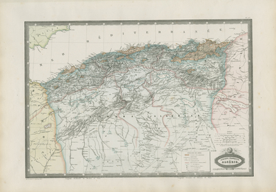
Uncommon map showing Algeria and its landforms in excellent detail. From "Atlas Spheroidal et Universel de Geographie" by M. F. A. Garnier, published in Paris at Veuve Jules Renouard in 1862. Decorative cartouche located on bottom right. Single paged, single sided map. 34 cm. x 49 cm. [Gift of Dr. Jack Franke]
Archival Date
1862
Collection Name
Maps of Africa
Collection Number
Acc. 2019-213
Language
French
Original Format
Maps
File Format
JPG
Rights
Rights held by The University of Texas at Arlington Libraries, Special Collections. Any use of content downloaded or printed from this page is limited to non-commercial personal or educational use, including fair use as directed by U.S. copyright laws. For more information or for reproduction requests, please contact UTA Special Collections by emailing spcoref@uta.edu.
License

This work is licensed under a Creative Commons Attribution-NonCommercial 4.0 International License
Subjects
Maps; Africa; Mountains; Cartouches (Graphic)