


Preview
Identifier
20086304
Description
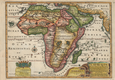
Colorful, copper plate engraved, map of Africa from Nicholas de Fer's "L'Atlas Curieux ou le Monde," an example of the third state dated to 1717. Neighboring regions of southern Europe, Persia, and Arabia included. Map contains a blend of known, mythical, and conjectured features. For example, southwest coastline between The Cape and The Congo has a convex bulge, the source of which is obscure. Unusual islands appear within the Atlantic and Indian Oceans, including the fictitious islands of the second St. Helena island, Saxenbourg, and Dos Romeiros. Featured within Central Africa, additional text details origin of Nile from Abyssinia; the source is close to accurate, but the two mythical lakes remain. Ptolemy's lakes of Zaire and Zaflan are depicted entirely divorced from the Nile. At Cape of Good Hope, appears a description on the circumnavigation completed by Diaz in 1486. The cartographer, Nicholas de Fer, became the official geographer to the Dauphin of France, Louis XV or XVI, and Spanish King, Charles VI. Decorative title cartouche located in bottom right corner, depicts kilns to the left. Cartographer includes dedication to the Dauphin in lower left corner, although does not specify which Dauphin (son or heir). Locale of various kingdoms and empires noted. A fleur-de-lis motif situated above compass rose, depicted within Atlantic Ocean. Regions delineated by various colors. Border surrounding map includes scale. Scale key is provided, beside title cartouche in bottom right corner. Landforms and waterways located throughout. Hachures depicted off coast(s). Single-paged, single-sided, horizontal map on laid paper. Folds as issued. Without binding or single centrefold. Verso is blank. 23 cm. x 32 cm. [Gift of Dr. Jack Franke]
Archival Date
1717
Collection Name
Maps of Africa
Collection Number
Acc. 2019-191
Language
French
Original Format
Maps
File Format
JPG
Rights
Rights held by The University of Texas at Arlington Libraries, Special Collections. Any use of content downloaded or printed from this page is limited to non-commercial personal or educational use, including fair use as directed by U.S. copyright laws. For more information or for reproduction requests, please contact UTA Special Collections by emailing spcoref@uta.edu.
License

This work is licensed under a Creative Commons Attribution-NonCommercial 4.0 International License
Subjects
Maps; Africa; Oceans; Mountains; Rivers; Cartouches (Graphic); Borders (Ornament areas)