


Preview
Identifier
20086316
Description
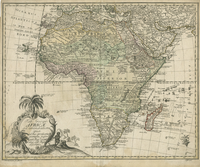
Copperplate engraved map of Africa, from the 1753 Paris edition of Euler's "Atlas," one of the first atlases intended for school use. Map was engraved for the Royal Prussian Academy Bellin. Map of the continent combines known details and speculations. The center of Africa is largely blank. The Sahara is referred to as the Barabary Desert. Surrounding regions of Southern Mediterranean Sea, Arabia, and Asia are highly detailed. Decorative title cartouche with vignette, (located in bottom left corner) depicts local inhabitant within a tropical landscape of trees and cliffs. A Prussian duty stamp printed in bottom right corner. Landforms and waterways depicted throughout. Regions delineated by various shaded colors. Border surrounding map includes scale. Scale key not provided. Hachures depicted off coast(s). Double-paged, single-sided, horizontal map on laid paper. Bound at centrefold on verso. Verso is blank. 40 cm. x 42 cm. [Gift of Dr. Jack Franke]
Archival Date
1753
Collection Name
Maps of Africa
Collection Number
Acc. 2019-180
Language
Latin
Original Format
Maps
File Format
JPG
Rights
Rights held by The University of Texas at Arlington Libraries, Special Collections. Any use of content downloaded or printed from this page is limited to non-commercial personal or educational use, including fair use as directed by U.S. copyright laws. For more information or for reproduction requests, please contact UTA Special Collections by emailing spcoref@uta.edu.
License

This work is licensed under a Creative Commons Attribution-NonCommercial 4.0 International License
Subjects
Maps; Africa; Oceans; Waterways; Islands; Deserts; Cartouches (Graphic)