


Preview
Identifier
20086315
Description
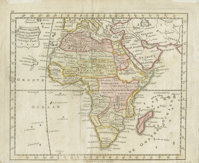
Rare miniature map of Africa, pubished in Amsterdam by Jan Elwe. The map appeared in his COMPLEETE ZAK-ATLAS, VAN DE ZEVENTIEN NEDERLANDSCHE PROVINCIËN. Colored with hachures and town/city names along continent coast. Plainly decorated cartouche on top right. Horizontal orientation, single paged, single sided. Slightly faint colored map. Originally folded twice, with two white tabs later added and located on top margin. 18 cm. x 22 cm. Dutch text. [Gift of Dr. Jack Franke]
Archival Date
1786
Collection Name
Maps of Africa
Collection Number
Acc. 2019-209
Language
Dutch
Original Format
Maps
File Format
JPG
Rights
Rights held by The University of Texas at Arlington Libraries, Special Collections. Any use of content downloaded or printed from this page is limited to non-commercial personal or educational use, including fair use as directed by U.S. copyright laws. For more information or for reproduction requests, please contact UTA Special Collections by emailing spcoref@uta.edu.
License

This work is licensed under a Creative Commons Attribution-NonCommercial 4.0 International License
Subjects
Maps; Africa; Oceans; Islands; Cartouches (Graphic); Miniature works