


Preview
Identifier
20086326
Description
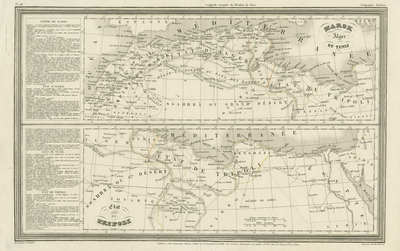
Two uncolored maps, printed on one page, oriented horizontally. Engraved map of North Africa including Empire of Morocco, Kingdom of Fes (Fez), states of Tunisia, Tripoli (in present Libya), Algeria and Egypt. Political boundaries lightly traced with color and landforms included within map. Details include many ports, cities, towns, oases and trade routes in the interior. Hachures depicted along Northern coast. Prepared by A. H. Dufour and engraved by Giraldon-Bovinet. Titles of maps located at top right (of top map), and bottom left (of bottom map). Table of statistics at left of maps, giving details on geographical, statistic and economical details of Empire of Morocco, State of Tunisia, and State of Tripoli. Publisher information and scale located at bottom. 27 cm. x 43 cm. [Gift of Dr. Jack Franke]
Archival Date
1846
Collection Name
Maps of Africa
Collection Number
Acc. 2019-354
Language
French
Original Format
Maps
File Format
JPG
Rights
Rights held by The University of Texas at Arlington Libraries, Special Collections. Any use of content downloaded or printed from this page is limited to non-commercial personal or educational use, including fair use as directed by U.S. copyright laws. For more information or for reproduction requests, please contact UTA Special Collections by emailing spcoref@uta.edu.
License

This work is licensed under a Creative Commons Attribution-NonCommercial 4.0 International License
Subjects
Maps; Deserts; Oases; Seas; Africa; Morocco; Tunisia; Tripoli (Libya); Egypt; Algeria