


Preview
Identifier
20086306
Description
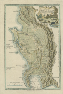
This colored, topographical map of the southwestern tip of Africa is F. A. Schraembl's reissue of Delarochette's 1782 map of region, originally published by William Faden. Spans from small island Klipping Eyland od. Klippen Insel, north of St. Helena Bay, south to Cape of Good Hope. Relief of Drakensberg mountain range depicted in great detail. Kraals, farms, settlements, salt works, fountains, crossings, routes, and other features accompanied with notes are depicted throughout map. Within surrounding waters are islands, depth soundings, and anchorages included. Two shades of blue outlines used to indicate surrounding coast (s) and shoreline(s). Three map keys provided and located within left side of map, one identifying sites of interest inland, the other of various islands and bays, and the third as a scale key in Dutch and British miles. Border around map includes scale. Decorative and colorful title cartouche, located at top right, features a cliff and African village surrounded by palm trees. Mounted colonial settlers on horseback hunt elephants with spears in the foreground. Elephants depicted within the map, near "Berg Fluss" (mountain river) with note "Stay with Elephants in December and January". Hachures depicted off coast(s). Map features locations of various tribes. Publisher information within bottom margin. Single-paged, single-sided, vertical map. 50 cm. x 33 cm. [Gift of Dr. Jack Franke]
Archival Date
1789
Collection Name
Maps of Africa
Collection Number
Acc. 2019-183
Language
Dutch
Original Format
Maps
File Format
JPG
Rights
Rights held by The University of Texas at Arlington Libraries, Special Collections. Any use of content downloaded or printed from this page is limited to non-commercial personal or educational use, including fair use as directed by U.S. copyright laws. For more information or for reproduction requests, please contact UTA Special Collections by emailing spcoref@uta.edu.
License

This work is licensed under a Creative Commons Attribution-NonCommercial 4.0 International License
Subjects
Maps; Waterways; Mountains; Rivers; Cartouches (Graphic); Topographic maps; Animals; Colonists