


Preview
Identifier
20086301
Description
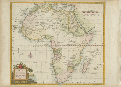
Colored map of African continent with surrounding islands. Title cartouche located in lower right includes a local inhabitant seated above, surrounded by flora and fauna supposedly local to the continent, including a lion, bird, camel, and the local wearing an elephant inspired headdress. The scene includes pyramids depicted in the distance. Map depicts neighboring regions of southern Mediterranean from lower Spain, Italy, and Anatolia with Arabia and Syria, to the Cape of Good Hope in the south. Parts of South Africa extend beyond printed border of map. Central Africa largely unmapped. Engraver found at center, within top margin of map. Compass Rose provided above title cartouche, within printed area of Ethiopian Sea. Border surrounding map includes scale. Scale key located in upper right corner with two different scale measurements. Hachures depicted along coast(s), while interior regions are delineated with lightly colored shading and outlines. Single-paged, single-sided, horizontal map. 33 cm. x 38 cm. [Gift of Dr. Jack Franke]
Archival Date
1779
Collection Name
Maps of Africa
Collection Number
Acc. 2019-170
Language
English
Original Format
Maps
File Format
JPG
Rights
Rights held by The University of Texas at Arlington Libraries, Special Collections. Any use of content downloaded or printed from this page is limited to non-commercial personal or educational use, including fair use as directed by U.S. copyright laws. For more information or for reproduction requests, please contact UTA Special Collections by emailing spcoref@uta.edu.
License

This work is licensed under a Creative Commons Attribution-NonCommercial 4.0 International License
Subjects
Maps; Africa; Oceans; Islands; Cartouches (Graphic)