


Preview
Identifier
20086308
Description
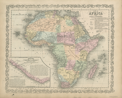
Detailed and colored map of Africa. Shows towns, rivers, lakes, railroads, routes, etc. with hachures along coasts. Lower left of map includes inset of the Republic of Liberia from Gurley's Report. Contains additional information of the geographical and historical context of Liberia. Unexplored region (modern day Congo) indicated on map. Key provided in upper right for listings (by name) of colonial holdings and regions (not by color). Scale in upper left, and ornamental design along border of map. Single paged, single sided, horizontal map, colored by country. Verso is blank, no centrefold or binding. 38 cm. x 32 cm. [Gift of Dr. Jack Franke]
Archival Date
1856
Collection Name
Maps of Africa
Collection Number
Acc. 2019-338
Language
English
Original Format
Maps
File Format
JPG
Rights
Rights held by The University of Texas at Arlington Libraries, Special Collections. Any use of content downloaded or printed from this page is limited to non-commercial personal or educational use, including fair use as directed by U.S. copyright laws. For more information or for reproduction requests, please contact UTA Special Collections by emailing spcoref@uta.edu.
License

This work is licensed under a Creative Commons Attribution-NonCommercial 4.0 International License
Subjects
Maps; Africa; Oceans; Mountains; Lakes; Cartouches (Graphic); Borders (Ornament areas); Colonies; Railroads