


Preview
Identifier
20086300
Description
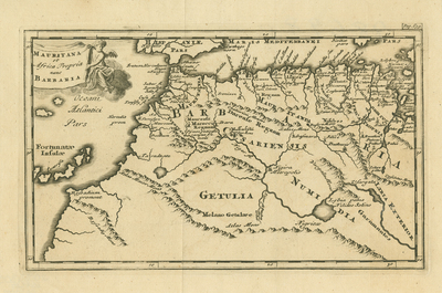
Engraved map of northwestern Africa with the Canary Islands ("Fortunatae Insulae"). At top left an angel holds a banner with the map's title. Attributed to Philipp Clüver (1580–1622), a geographer and historian from Danzig (Gdansk) who settled in Leiden. Page number included in top right corner of map. Single-sided, single-paged uncolored horizontal map. Latin text. 13 cm. x 22 cm. [Gift of Dr. Jack Franke]
Archival Date
1700
Collection Name
Maps of Africa
Collection Number
Acc. 2019-380
Language
Latin
Original Format
Maps
File Format
JPG
Rights
Rights held by The University of Texas at Arlington Libraries, Special Collections. Any use of content downloaded or printed from this page is limited to non-commercial personal or educational use, including fair use as directed by U.S. copyright laws. For more information or for reproduction requests, please contact UTA Special Collections by emailing spcoref@uta.edu.
License

This work is licensed under a Creative Commons Attribution-NonCommercial 4.0 International License
Subjects
Maps; Oceans; Islands; Mountains; Cartouches (Graphic)