


Preview
Identifier
20086299
Description
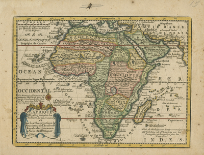
Small, hand-colored map of Africa compiled, engraved, and published in Paris in 1719 by Jacques Chiquet. Regions distinguished by color. Westward flowing Niger River inaccurately confused with the Senegal and the Gambia rivers. Includes a decorative and colorful cartouche at bottom left corner of map. Plain border surrounding map includes scale. Scale key located at top left. Hachures depicted along coast lines. Annotations accompany map throughout. Major landforms included. Latitude lines of Equator and Tropics of Cancer and Capricorn especially noticeably printed. Single-paged, single-sided horizontal map. 17 cm. x 22 cm. [Gift of Dr. Jack Franke]
Archival Date
1719
Collection Name
Maps of Africa
Collection Number
Acc. 2019-278
Language
French
Original Format
Maps
File Format
JPG
Rights
Rights held by The University of Texas at Arlington Libraries, Special Collections. Any use of content downloaded or printed from this page is limited to non-commercial personal or educational use, including fair use as directed by U.S. copyright laws. For more information or for reproduction requests, please contact UTA Special Collections by emailing spcoref@uta.edu.
License

This work is licensed under a Creative Commons Attribution-NonCommercial 4.0 International License
Subjects
Maps; Rivers; Oceans; Islands; Cartouches (Graphic)