


Preview
Identifier
20086292
Description
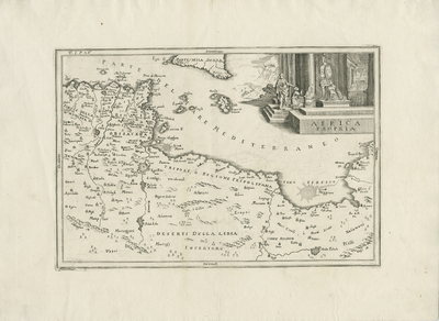
Uncolored map of northern African coastlines of Tunisia and Libya. Map shows neighboring regions to the north including Sicily, the island of Malta, and the surrounding smaller islands. The map depicts the region in Roman times; the title cartouche in the upper right corner shows a Roman emperor in full military armor among ancient Grecian architecture with "Africa Propria" inscribed on the staircase. Map includes an engraving of Great Syrtic and Little Syrtis, a pair of very dangerous sandbanks off the coast of Libya, most hazardous to any shipping vessel sailing at the time. Vegetation, landforms, waterways, and settlements depicted throughout map. Hachures seen off coast(s). No map key provided. Double-paged, single-sided, horizontal map on laid paper. Centrefold bound at verso. Verso is blank. 20 cm. x 30 cm. [Gift of Dr. Jack Franke]
Archival Date
1760
Collection Name
Maps of Africa
Collection Number
Acc. 2019-230
Language
Italian
Original Format
Maps
File Format
JPG
Rights
Rights held by The University of Texas at Arlington Libraries, Special Collections. Any use of content downloaded or printed from this page is limited to non-commercial personal or educational use, including fair use as directed by U.S. copyright laws. For more information or for reproduction requests, please contact UTA Special Collections by emailing spcoref@uta.edu.
License

This work is licensed under a Creative Commons Attribution-NonCommercial 4.0 International License
Subjects
Maps; Seas; Islands; Cartouches (Graphic)