


Preview
Identifier
20086291
Description
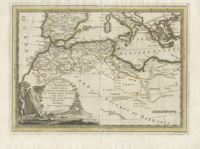
Uncolored map of northwestern Africa, from the 'Nuovo Atlante Geografico Universale,' an unsuccessful publication and therefore scarce. Map begins at Pamplona, Spain, and extends south into the Sahara Desert. Decorative title cartouche located in lower left contains small landscape scene, two humans, vegetation/terrain, and animal predator on top of one male human wearing a headwrap. Hachures depicted off coast(s). Various landforms and waterways located throughout region. Neighboring Spain included in great detail along with general parts of Italy, its islands, and modern day Turkey. Border surrounding map includes scale and color. Regions within northern Africa are delineated with various colored outlines, matching neighboring country outlines in color, indicating respectively colonial regions (without key). Scale key provided in lower right. Map features locations of various tribes. Double-paged, single-sided, horizontal map bound on verso at centrefold. 34 cm. x 46.5 cm. [Gift of Dr. Jack Franke]
Archival Date
1789
Collection Name
Maps of Africa
Collection Number
Acc. 2019-242
Language
Italian
Original Format
Maps
File Format
JPG
Rights
Rights held by The University of Texas at Arlington Libraries, Special Collections. Any use of content downloaded or printed from this page is limited to non-commercial personal or educational use, including fair use as directed by U.S. copyright laws. For more information or for reproduction requests, please contact UTA Special Collections by emailing spcoref@uta.edu.
License

This work is licensed under a Creative Commons Attribution-NonCommercial 4.0 International License
Subjects
Maps; Waterways; Deserts; Islands; Mountains; Cartouches (Graphic)