


Preview
Identifier
20086290
Description
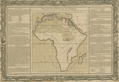
General map of Africa. Accompanied with two columns of text within left and right margins, framing map print. Columns discuss historical context of general regions depicted. Cartographer indicates source of the Nile originating from the fictitious "Mountains of the Moon." Much of the continent's interior is not identified. Regions labeled generally and delineated by colored outlines. Title located at top center. Border surrounding map includes scale. Scale key not provided. Outermost decorative border encompasses map's print and accompanying text; features flora, vegetation, motifs, and some imagery. Hachures depicted off coast(s). Landforms and waterways located throughout. Single-paged, single-sided, horizontal map on laid paper with watermark. [Gift of Dr. Jack Franke]
Archival Date
1761
Collection Name
Maps of Africa
Collection Number
Acc. 2019-223
Language
French
Original Format
Maps
File Format
JPG
Rights
Rights held by The University of Texas at Arlington Libraries, Special Collections. Any use of content downloaded or printed from this page is limited to non-commercial personal or educational use, including fair use as directed by U.S. copyright laws. For more information or for reproduction requests, please contact UTA Special Collections by emailing spcoref@uta.edu.
License

This work is licensed under a Creative Commons Attribution-NonCommercial 4.0 International License
Subjects
Maps; Africa; Oceans; Mountains; Rivers; Borders (Ornament areas)