


Preview
Identifier
20086289
Description
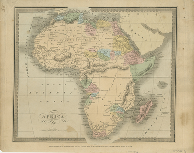
Colored map of Africa. Tribal regions are distinguished by color. Hachures are included, surrounding the continent to indicate coast. Mountain ranges and landforms are located throughout. Interior of Africa is labeled as unexplored region. Title and scale located at bottom left. Publisher information within bottom margin. Border surrounding the map is standard and includes scale. Single page, single sided, horizontal map. Page is visibly uneven, especially along top edge. 32 cm. x 27 cm. [Gift of Dr. Jack Franke]
Archival Date
1836
Collection Name
Maps of Africa
Collection Number
Acc. 2019-340
Language
English
Original Format
Maps
File Format
JPG
Rights
Rights held by The University of Texas at Arlington Libraries, Special Collections. Any use of content downloaded or printed from this page is limited to non-commercial personal or educational use, including fair use as directed by U.S. copyright laws. For more information or for reproduction requests, please contact UTA Special Collections by emailing spcoref@uta.edu.
License

This work is licensed under a Creative Commons Attribution-NonCommercial 4.0 International License
Subjects
Maps; Deserts; Mountains; Indigenous peoples