


Preview
Identifier
20086286
Description
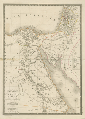
Uncolored map of ancient Egypt including Palestine and Arabia by Brué, from his "Atlas Universel," engraved by L'Auteur. Outlines delineated by color, indicating regions. Hachures printed along coastal lands. Waterways and landforms located throughout Egypt, Arabia Petraea, and Palastina. Southernmost tips of Syria (Coele Syria) and modern day Lebanon included. Legend located within right side of map near Arabia Desert. Border surrounding map includes scale. Scale and cursive title located in lower left corner. Publisher information within bottom and right margin. Double-paged, single-sided, vertical map. Bound at centrefold on verso. 52 cm. x 37 cm. [Gift of Dr. Jack Franke]
Archival Date
1822
Collection Name
Maps of Africa
Collection Number
Acc. 2019-309
Language
French
Original Format
Maps
File Format
JPG
Rights
Rights held by The University of Texas at Arlington Libraries, Special Collections. Any use of content downloaded or printed from this page is limited to non-commercial personal or educational use, including fair use as directed by U.S. copyright laws. For more information or for reproduction requests, please contact UTA Special Collections by emailing spcoref@uta.edu.
License

This work is licensed under a Creative Commons Attribution-NonCommercial 4.0 International License
Subjects
Maps; Waterways; Seas; Mountains