


Preview
Identifier
20086285
Description
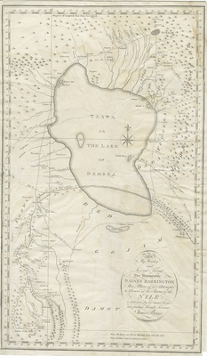
Uncolored map of Ethiopia (Abyssinia) and the source of the Blue Nile by the Scottish adventurer James Bruce. Centered on Lake Tana (Tzana), this map covers from the Ethiopian capital at Gondar to as far south as Geesh Abay (Geesh Springs), the source of the Nile. Many claim that this map and Bruce's explorations were in search of Templar artifacts including, among other things, the Ark of the Covenant. Most Ethiopians strongly believe that the Ark resides in the Coptic sanctuary of Axum, which Bruce indeed visited. Engraved by J. Walker for James Bruce's 1790 book, “Travels to Discover the Source of the Nile.” Title located in bottom right. Map border includes scale. No map key provided regarding scale of distances. Cartographer includes small key in bottom right, indicating routes taken by Mr. Bruce alone and with the king/army. Landforms and bodies of water/waterways located throughout region. Compass rose provided within depiction of Lake Tzana. Double-paged, single-sided, vertical map. 53 cm. x 31 cm. [Gift of Dr. Jack Franke]
Archival Date
1790
Collection Name
Maps of Africa
Collection Number
Acc. 2019-178
Language
English
Original Format
Maps
File Format
JPG
Rights
Rights held by The University of Texas at Arlington Libraries, Special Collections. Any use of content downloaded or printed from this page is limited to non-commercial personal or educational use, including fair use as directed by U.S. copyright laws. For more information or for reproduction requests, please contact UTA Special Collections by emailing spcoref@uta.edu.
License

This work is licensed under a Creative Commons Attribution-NonCommercial 4.0 International License
Names
Ethopia; Blue Nile; Bruce, James; Lake Tana; Geesh Abay; Ark of the Covenant; Walker, J.; Travels to Discover the Source of the Nile
Subjects
Maps; Waterways; Cartouches (Graphic)