


Preview
Identifier
20086284
Description
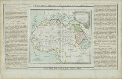
Lightly colored map of northwestern Africa with an elaborate title cartouche in upper right corner of map. On either side of print is original letter-press descriptive text relating to geographical area depicted. This text has been separately printed and affixed on either side prior to issue by the publisher. The White Nile flows south into the Ptolemaic Mountains of the Moon. According to Ptolemy, the Mountains of the Moon lay near two great lakes that were source of the White Nile. Today some regard this range and its lakes as speculative, but more likely it represents Ptolemy's very real knowledge of Lake Victoria and the Rwenzori Mountains. Hachures depicted off coast(s). Landforms and waterways located throughout. Neighboring regions of Arabia and southern Mediterranean generally included. Regions within continent delineated by various colored outlines and shading. Surrounding border of map includes scale. Scale key in lower left. Various tribes noted throughout. Double-paged, single-sided, horizontal map with original centrefold. Without binding. 33 cm. x 50 cm. [Gift of Dr. Jack Franke]
Archival Date
1790
Collection Name
Maps of Africa
Collection Number
Acc. 2019-301
Language
French
Original Format
Maps
File Format
JPG
Rights
Rights held by The University of Texas at Arlington Libraries, Special Collections. Any use of content downloaded or printed from this page is limited to non-commercial personal or educational use, including fair use as directed by U.S. copyright laws. For more information or for reproduction requests, please contact UTA Special Collections by emailing spcoref@uta.edu.
License

This work is licensed under a Creative Commons Attribution-NonCommercial 4.0 International License
Subjects
Maps; Waterways; Deserts; Mountains; Cartouches (Graphic)