


Preview
Identifier
20086281
Description
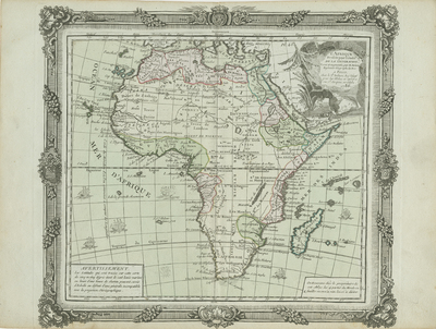
Colored, copper engraved map of Africa published in Louis Brion de la Tour's, "Atlas general civil, ecclesiastique et militaire, methodique et elementaire pour l'etude de la geographie et de l'histoire," in Paris. Map has two borders, featuring decorative outside border, and interior border; surrounding map contains scale. Scale key not provided. Decorative title cartouche located in top right corner of map, depicting small seascape and flora. Locale of various tribes and ruling factions noted. Source of Nile originates from the fictitious "Mountains of the Moon." Hachures depicted off coast(s). Cartographer adds warning, in bottom left corner, on latitudes of the map. Additional text provided in bottom right corner. Various ships are depicted within sea/ocean regions. Double-paged, single-sided, horizontal map. 28 cm. x 31 cm. [Gift of Dr. Jack Franke]
Archival Date
1786
Collection Name
Maps of Africa
Collection Number
Acc. 2019-255
Language
French
Original Format
Maps
File Format
JPG
Rights
Rights held by The University of Texas at Arlington Libraries, Special Collections. Any use of content downloaded or printed from this page is limited to non-commercial personal or educational use, including fair use as directed by U.S. copyright laws. For more information or for reproduction requests, please contact UTA Special Collections by emailing spcoref@uta.edu.
License

This work is licensed under a Creative Commons Attribution-NonCommercial 4.0 International License
Subjects
Maps; Rivers; Mountains; Cartouches (Graphic); Borders (Ornament areas)