


Preview
Identifier
20086282
Description
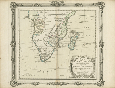
Subtly colored map of southern Africa and Madagascar with a decorative floral border. Scale border accompanies floral border. Scale key located in bottom left corner. Title cartouche located in bottom right corner, surrounded by decorative border including vegetation. Regions delineated with light coloring, some are shaded. Map begins at Kingdom of Benin and spans to the Cape of Good Hope within southernmost tip of mainland. Landforms and waterways depicted throughout region. Locale of various tribes noted. Double-paged, single-sided, horizontal map. 30 cm. x 28 cm. [Gift of Dr. Jack Franke]
Archival Date
1766
Collection Name
Maps of Africa
Collection Number
Acc. 2019-353
Language
French
Original Format
Maps
File Format
JPG
Rights
Rights held by The University of Texas at Arlington Libraries, Special Collections. Any use of content downloaded or printed from this page is limited to non-commercial personal or educational use, including fair use as directed by U.S. copyright laws. For more information or for reproduction requests, please contact UTA Special Collections by emailing spcoref@uta.edu.
License

This work is licensed under a Creative Commons Attribution-NonCommercial 4.0 International License
Subjects
Maps; Rivers; Mountains; Islands; Cartouches (Graphic); Borders (Ornament areas)