


Preview
Identifier
20086280
Description
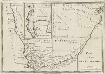
An uncolored, engraved map of the Cape of Good Hope in South Africa. Map includes inset of False Bay, located left of center, within printed area of South Africa. Map spans from 'Cafrerie' (Kaffraria in English) in the north, to False Bay in the south, and focuses on including coastal regions. Published in 1780 by Louis Brion de la Tour. Louis Brion de la Tour (1743–1803) was an 18th-century French geographer and demographer. His official title was Ingénieur Géographe du Roi ("King's Engineer Geographer"). Title of map and scale key located at bottom right. Border surrounding map includes scale. Landforms and waterways depicted throughout. Hachures included along coast(s). Words "Tom. 64. Pag. 425" printed in upper right corner. Longitude guides from Paris and Isle de Fer, in reference to the depicted region of south Africa, located at center within top and bottom margins. Single-paged, single-sided, horizontal map with multiple folds as issued. 24 cm. x 34 cm. [Gift of Dr. Jack Franke]
Archival Date
1780
Collection Name
Maps of Africa
Collection Number
Acc. 2019-270
Language
French
Original Format
Maps
File Format
JPG
Rights
Rights held by The University of Texas at Arlington Libraries, Special Collections. Any use of content downloaded or printed from this page is limited to non-commercial personal or educational use, including fair use as directed by U.S. copyright laws. For more information or for reproduction requests, please contact UTA Special Collections by emailing spcoref@uta.edu.
License

This work is licensed under a Creative Commons Attribution-NonCommercial 4.0 International License
Subjects
Maps; Oceans; Coastlines; Islands; Waterways