


Preview
Identifier
20086278
Description
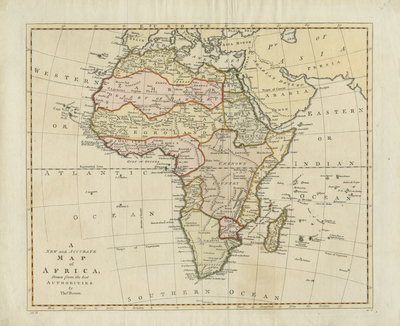
Lightly colored map of Africa divided into kingdoms, published in Middleton's "Complete System of Geography." Illustrates a largely unknown interior of Africa, dominated by "Nigritia" or "Negroland." Neighboring regions of Arabia, Persia, Asia Minor, and southern Mediterranean generally included. Surrounding islands of Africa depicted. The African Great Lakes are almost entirely missing from the map. The Niger River is shown incorrectly as an endorheic (closed) river system flowing into a lake in the approximate location of Lake Chad; it in fact turns south and flows into the sea in the Gulf of Guinea. The Nile is still shown with its headwaters in two lakes, located in the Mounts of the Moon, above the equator. Surrounding map border includes scale. Regions delineated by outlined and shaded colors. Map key not provided. Title and cartographer information in lower left. Hachures depicted off coast(s). Landforms and waterways located. Various tribes noted throughout continent. Single-paged, single-sided, horizontal map with original folds. 34 cm. x 41 cm. [Gift of Dr. Jack Franke]
Archival Date
1795
Collection Name
Maps of Africa
Collection Number
Acc. 2019-302
Language
English
Original Format
Maps
File Format
JPG
Rights
Rights held by The University of Texas at Arlington Libraries, Special Collections. Any use of content downloaded or printed from this page is limited to non-commercial personal or educational use, including fair use as directed by U.S. copyright laws. For more information or for reproduction requests, please contact UTA Special Collections by emailing spcoref@uta.edu.
License

This work is licensed under a Creative Commons Attribution-NonCommercial 4.0 International License
Subjects
Maps; Africa; Oceans; Rivers; Islands