


Preview
Identifier
20086277
Description
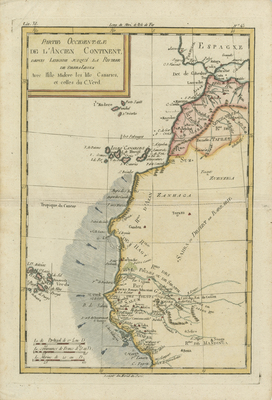
Colored map of northwestern coast of Africa, covering Morocco, Western Sahara, Mauritania, Algeria, modern day Senegal and Gambia (labeled Pays Galam, or kingdom of Galam, as an ancient kingdom of Senegal), and Biafra (eastern region of Nigeria). Includes the Canary Islands, Madeira Island, and Cape Verde Islands. Map spans from Lisbon, Portugal, southern Spain generally, Morocco, to south of Biafra kingdom in Africa. Minimal inland details and boundaries reflect the paucity of knowledge about interior continent. The exceptions are Senegal and the Gambia river valleys, extending inland from Cape Verde, which were just being discovered and mapped during the time. Arrows and hachures depicted along Atlantic show ocean and wind currents along coast(s), which made this region difficult to navigate during early African explorations. Colored title cartouche located in upper left corner. Border surrounding map includes scale. Scale key provided in lower left corner with three scale measurements. Regions outlined by various colors and shading. General landforms and waterways located throughout northwestern coast. Double-paged, single-sided, vertical map. 33 cm. x 23 cm. [Gift of Dr. Jack Franke]
Archival Date
1780
Collection Name
Maps of Africa
Collection Number
Acc. 2019-314
Language
French
Original Format
Maps
File Format
JPG
Rights
Rights held by The University of Texas at Arlington Libraries, Special Collections. Any use of content downloaded or printed from this page is limited to non-commercial personal or educational use, including fair use as directed by U.S. copyright laws. For more information or for reproduction requests, please contact UTA Special Collections by emailing spcoref@uta.edu.
License

This work is licensed under a Creative Commons Attribution-NonCommercial 4.0 International License
Subjects
Maps; Capes(Coastal); Islands; Oceans; Cartouches (Graphic)