


Preview
Identifier
20086279
Description
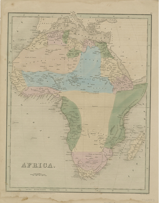
Colored map of Africa showing the extent of discoveries and claims within the interior, distinguished by color. Parts surrounding Arabia and Mediterranean are depicted. Interior of continent has less detail, which was still largely unexplored during the time. Hachures are included along the continent's coast. Title and scale of map located at bottom left. Border surrounding the map includes scale in miles. Publisher information in bottom margin. Single-page, single-sided, vertical map. 38 cm. x 30 cm. [Gift of Dr. Jack Franke]
Archival Date
1846
Collection Name
Maps of Africa
Collection Number
Acc. 2019-341
Language
English
Original Format
Maps
File Format
JPG
Rights
Rights held by The University of Texas at Arlington Libraries, Special Collections. Any use of content downloaded or printed from this page is limited to non-commercial personal or educational use, including fair use as directed by U.S. copyright laws. For more information or for reproduction requests, please contact UTA Special Collections by emailing spcoref@uta.edu.
License

This work is licensed under a Creative Commons Attribution-NonCommercial 4.0 International License
Subjects
Maps; Africa; Oceans; Discovery & exploration