


Preview
Identifier
20086276
Description
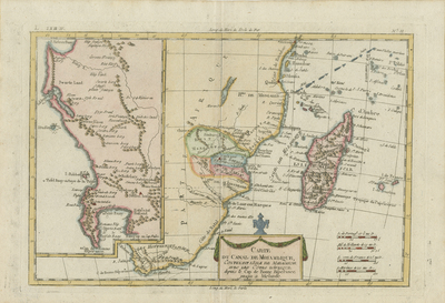
Colored map of the southeastern coast of Africa, from Mombasa to Cape Town, including Zanzibar, Madagascar, and surrounding islands. Depicts trade winds/currents' direction using arrows within Indian ocean. Decorative and colored title cartouche located at bottom, near center of map. The islands of Mauritius (I. de France) and Reunion (I. de Bourbon) are included, right to Madagascar. Regions of the continent delineated by various shaded colors and outlines. Inset located along left side, shows Cape of Good Hope and parts of the surrounding region. Border around map includes scale. Scale key in lower right corner provides four different scale measurements. Hachures depicted off coast(s) within a blue outline of continent. Locale of various tribes, landforms, and waterways noted throughout region. Double-paged, single-sided, horizontal map. 21 cm. x 32 cm. [Gift of Dr. Jack Franke]
Archival Date
1780
Collection Name
Maps of Africa
Collection Number
Acc. 2019-317
Language
French
Original Format
Maps
File Format
JPG
Rights
Rights held by The University of Texas at Arlington Libraries, Special Collections. Any use of content downloaded or printed from this page is limited to non-commercial personal or educational use, including fair use as directed by U.S. copyright laws. For more information or for reproduction requests, please contact UTA Special Collections by emailing spcoref@uta.edu.
License

This work is licensed under a Creative Commons Attribution-NonCommercial 4.0 International License
Names
Cape Town; Zanzibar; Madagascar; Cape of Good Hope
Subjects
Maps; Capes(Coastal); Islands; Oceans; Cartouches (Graphic); Waterways