


Preview
Identifier
20086275
Description
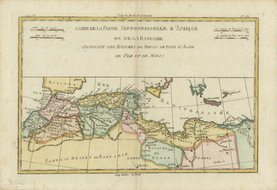
Colored map of the Barbary Coast including northern Sahara and northwestern region of Egypt. Neighboring regions of Sicily, southern Spain, and Greek islands of Crete and the Peloponnese are depicted within the southern Mediterranean. Border surrounding map includes scale. Title and scales located within top section of page. Two sets of scale keys are provided within top section, accompanying title in upper left and right corner, providing a total of four scale measurements. Regions delineated by various outlined colors and shading. Hachures depicted off coast(s). Landforms located throughout region. Double-paged, single-sided, horizontal map. 23 cm. x 33 cm. [Gift of Dr. Jack Franke]
Archival Date
1780
Collection Name
Maps of Africa
Collection Number
Acc. 2019-315
Language
French
Original Format
Maps
File Format
JPG
Rights
Rights held by The University of Texas at Arlington Libraries, Special Collections. Any use of content downloaded or printed from this page is limited to non-commercial personal or educational use, including fair use as directed by U.S. copyright laws. For more information or for reproduction requests, please contact UTA Special Collections by emailing spcoref@uta.edu.
License

This work is licensed under a Creative Commons Attribution-NonCommercial 4.0 International License
Subjects
Maps; Islands; Deserts; Coastlines; Seas