


Preview
Identifier
20086274
Description
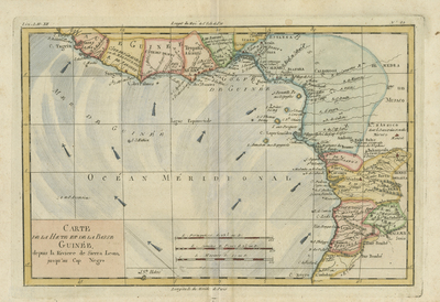
Colored map of Africa's Guinea coast (upper and lower). Map corresponds to modern day Liberia, Ivory Coast, Ghana, Nigeria, Cameroon, Gabon, Congo, and Equatorial Guinea. Map spans from the entire Guinea coast, the Sierra Leone River, to Cape Negro. Arrows indicating ocean/wind currents depicted within Atlantic coast of west Africa. Hachures added lightly to indicate coast(s)/shoreline(s). Map features towns, rivers, some topography, and political boundaries. Border surrounding map includes scale. Scale key provided with three different scale measurements and located at bottom center. Title located left of scale. Double-paged, single-sided, horizontal map. 25 cm. x 37 cm. [Gift of Dr. Jack Franke]
Archival Date
1780
Collection Name
Maps of Africa
Collection Number
Acc. 2019-313
Language
French
Original Format
Maps
File Format
JPG
Rights
Rights held by The University of Texas at Arlington Libraries, Special Collections. Any use of content downloaded or printed from this page is limited to non-commercial personal or educational use, including fair use as directed by U.S. copyright laws. For more information or for reproduction requests, please contact UTA Special Collections by emailing spcoref@uta.edu.
License

This work is licensed under a Creative Commons Attribution-NonCommercial 4.0 International License
Subjects
Maps; Coastlines; Oceans; Winds