


Preview
Identifier
20086273
Description
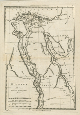
Uncolored map of Egypt published by Rigobert Bonne, the Royal Hydrographer to the King of France. As a hydroprapher, Bonne took careful consideration to detail physical features near the Nile River and coastal regions. Bonne depicts the slopes and contours of the Nile and surveys its underwater land terrain. This map shows the Nile River from the mouth to the Tropic of Cancer. Neighboring regions of Arabia and Palestine included. Engraver, Andres, noted in lower left corner. Surrounding border of map includes scale. Scale key and map title located in lower left. Hachures depicted off coast(s). Landforms and waterways visually emphasized within map. Publisher information located within bottom margin. Double-paged, single-sided, vertical map with original centrefold. Without binding. 36 cm. x 24 cm. [Gift of Dr. Jack Franke]
Archival Date
1787
Collection Name
Maps of Africa
Collection Number
Acc. 2019-316
Language
Latin
Original Format
Maps
File Format
JPG
Rights
Rights held by The University of Texas at Arlington Libraries, Special Collections. Any use of content downloaded or printed from this page is limited to non-commercial personal or educational use, including fair use as directed by U.S. copyright laws. For more information or for reproduction requests, please contact UTA Special Collections by emailing spcoref@uta.edu.
License

This work is licensed under a Creative Commons Attribution-NonCommercial 4.0 International License
Subjects
Maps; Africa; Rivers; Waterways