


Preview
Identifier
20086272
Description
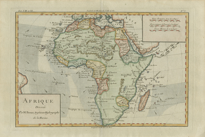
Colored map of Africa and surrounding islands including Madagascar, and portions of South America (to left) with Arabia (to right) for geographical context provided. Arrows depicted within Atlantic and Indian Oceans indicate currents. Diagonal hatching and light blue shading accompany the arrows within the bodies of water, to emphasize direction of currents. Border surrounding map includes scale. Scale key provided in upper right, with three different scale measurements. Title cartouche located in bottom left corner. Regions delineated by various colored shades and outlines. Hachures lightly depicted off coast(s) within a blue outline of whole continent. Locale of various tribes noted throughout. Landforms and waterways of continent included. Double-paged, single-sided, horizontal map. 26 cm. x 35 cm. [Gift of Dr. Jack Franke]
Archival Date
1780
Collection Name
Maps of Africa
Collection Number
Acc. 2019-284
Language
French
Original Format
Maps
File Format
JPG
Rights
Rights held by The University of Texas at Arlington Libraries, Special Collections. Any use of content downloaded or printed from this page is limited to non-commercial personal or educational use, including fair use as directed by U.S. copyright laws. For more information or for reproduction requests, please contact UTA Special Collections by emailing spcoref@uta.edu.
License

This work is licensed under a Creative Commons Attribution-NonCommercial 4.0 International License
Subjects
Maps; Africa; Oceans; Cartouches (Graphic); Waterways