


Preview
Identifier
20086269
Description
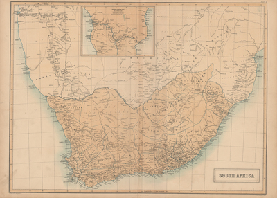
This large color map is from Black's "General Atlas of The World," published by Adam & Charles Black, Edinburgh, 1858. Contains an inset of Dr. Livingstone's travels at top center of map. Various Bushmen tribes shown throughout Southern Africa. Double-paged, single-sided horizontal map bound at centrefold. 22 cm. x 32 cm. [Gift of Dr. Jack Franke]
Archival Date
1858
Collection Name
Maps of Africa
Collection Number
Acc. 2019-385
Language
English
Original Format
Maps
File Format
JPG
Rights
Rights held by The University of Texas at Arlington Libraries, Special Collections. Any use of content downloaded or printed from this page is limited to non-commercial personal or educational use, including fair use as directed by U.S. copyright laws. For more information or for reproduction requests, please contact UTA Special Collections by emailing spcoref@uta.edu.
License

This work is licensed under a Creative Commons Attribution-NonCommercial 4.0 International License
Subjects
Maps; Atlases; Africa; Southern--Maps