


Preview
Identifier
20086268
Description
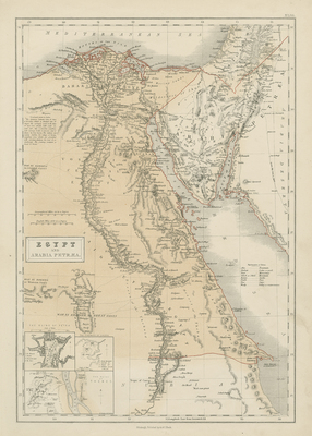
This large map is from Black's "General Atlas of The World," published by Adam & Charles Black, Edinburgh, 1858. This is a fine example of Adam and Charles Black's 1851 map of Egypt and the Sinai. It covers modern day Egypt as well as parts of adjacent, Palestine, Israel, Sudan, and Jordan. Three insets in the lower left quadrant detail 'The Ruins of Petra,' 'The Pyramid of Ghizeh' (Giza) and 'The Ruins of Thebes.' Several routes allegedly to the Syrian Haj route to Mecca, the Egyptian Haj route to Mecca and the overland route to India with slight inaccuracy of destination location (Mecca). A small note near the left margin describes the carriage and the time taken on the overland route to India. Translations of eight Arabic words into English included on right side of map. Single-paged, single-sided vertical map. 32 cm. x 43 cm. [Gift of Dr. Jack Franke]
Archival Date
1858
Collection Name
Maps of Africa
Collection Number
Acc. 2019-386
Language
English;Arabic
Original Format
Maps
File Format
JPG
Rights
Rights held by The University of Texas at Arlington Libraries, Special Collections. Any use of content downloaded or printed from this page is limited to non-commercial personal or educational use, including fair use as directed by U.S. copyright laws. For more information or for reproduction requests, please contact UTA Special Collections by emailing spcoref@uta.edu.
License

This work is licensed under a Creative Commons Attribution-NonCommercial 4.0 International License
Subjects
Maps; Atlases; Mountains; Coastlines; Seas