


Preview
Identifier
20086266
Description
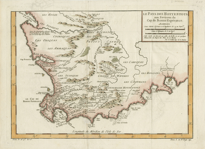
Colored map of South Africa, including territory of the "Hottentots," a derogatory Dutch term, and today preferably known as the Khoikhoi. Title and scale of two measurements are located within top right. Border surrounding map includes scale; excluding the top border. Map spans from Saint Helena Bay in north to Cape of Good Hope, Le Cap de Bonne Esperance, in south. Includes surrounding islands of mainland Africa. Hachures depicted off coast(s). Landforms, vegetation, and waterways generally illustrated and colored throughout. Locale of various tribes noted. "Tome 3. in 80 Page 391" printed within bottom right margin. "Longitude from south of l'Isle de Fer" printed within bottom of page, above bottom border of scale. Double-paged, single-sided, horizontal map. Bound near centerfold on verso. 40 cm . x 29 cm. [Gift of Dr. Jack Franke]
Archival Date
1770
Collection Name
Maps of Africa
Collection Number
Acc. 2019-400
Language
French
Original Format
Maps
File Format
JPG
Rights
Rights held by The University of Texas at Arlington Libraries, Special Collections. Any use of content downloaded or printed from this page is limited to non-commercial personal or educational use, including fair use as directed by U.S. copyright laws. For more information or for reproduction requests, please contact UTA Special Collections by emailing spcoref@uta.edu.
License

This work is licensed under a Creative Commons Attribution-NonCommercial 4.0 International License
Subjects
Maps; Africa; Islands; Oceans; Capes(Coasts); Coastlines; Waterways