


Preview
Identifier
20086259
Description
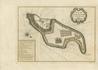
Colored and illustrated map of Gorée Island, one of the largest trading outposts for the slave trade along the African coast. Features include a site plan, topographical features such the rocky plateau (surrounding the island), and a mountain range within the southern tip (ensuring slaves could not escape, due to strategic location and topography). Two map keys provided. First key located in bottom left corner, lists different defense mechanisms on the island. Second map key is of scale measurements, and located beneath title cartouche. Decorative title cartouche located in top right corner. Hachures depicted off coast. French compass rose provided left of map, with small fleur-de-lis motif printed beside. Numbers surrounding the island indicate ocean depth. Cartographer notes where ships can safely debark, along the sandy beach to the north. Trying to debark near mainland Africa, which had steep and rocky coasts, made access difficult. European nations would stop at this accessible outpost to obtain slaves. Map's border serves as boundary; does not have elaborate/functional surrounding border. Single-paged, single-sided, horizontal map on laid paper, with three vertical folds as issued. 19 cm. x 27 cm. [Gift of Dr. Jack Franke]
Archival Date
1749
Collection Name
Maps of Africa
Collection Number
Acc. 2019-240
Language
French
Original Format
Maps
File Format
JPG
Rights
Rights held by The University of Texas at Arlington Libraries, Special Collections. Any use of content downloaded or printed from this page is limited to non-commercial personal or educational use, including fair use as directed by U.S. copyright laws. For more information or for reproduction requests, please contact UTA Special Collections by emailing spcoref@uta.edu.
License

This work is licensed under a Creative Commons Attribution-NonCommercial 4.0 International License
Subjects
Maps; Africa; Islands; Oceans; Cartouches (Graphic); Coastlines; Slave trade