


Preview
Identifier
20086264
Description
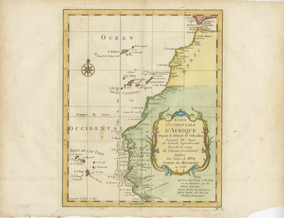
Colored map of northwestern African coast. Includes Canary Islands, Cape Verde Islands, and Portuguese island of Madeira. Map begins south of Strait of Gibralter in Spain (strait connecting Atlantic Ocean to the Mediterranean Sea, and separates Spain in Europe from Morocco in Africa), including Senegal, and modern day The Gambia. Decorative title cartouche located within Senegal's blank interior. Compass rose provided within Atlantic Ocean, with small fleur-de-lis motif above. Border surrounding map includes scale. Scale key not provided. Cartographer includes notes on longitude and latitude of map, below title cartouche. Landforms and waterways depicted generally along coast(s). Regions delineated with shaded colors. Double-paged, single-sided, horizontal page, with vertical print of map. Bound at centrefold on verso. 25 cm. x 20 cm. [Gift of Dr. Jack Franke]
Archival Date
1740
Collection Name
Maps of Africa
Collection Number
Acc. 2019-321
Language
French
Original Format
Maps
File Format
JPG
Rights
Rights held by The University of Texas at Arlington Libraries, Special Collections. Any use of content downloaded or printed from this page is limited to non-commercial personal or educational use, including fair use as directed by U.S. copyright laws. For more information or for reproduction requests, please contact UTA Special Collections by emailing spcoref@uta.edu.
License

This work is licensed under a Creative Commons Attribution-NonCommercial 4.0 International License
Subjects
Maps; Africa; Islands; Oceans; Cartouches (Graphic); Coastlines; Waterways